

Colorado
Step 1. Review
Review population trends with Coloradans On the Move, an interactive demonstration of population movement in the state over three time periods.
- Demographic Summary 2022, Colorado State Demography Office, February 13, 2022
- Pre-assessment for Colorado (for use in classrooms)
- General questions about redistricting
Step 2. Discuss

Discuss how to prioritize redistricting criteria using Flashes of Insight cards or an online game.
- Local Redistricting in Colorado: Laws and Criteria (background)
- More States Move to Nonpartisan Redistricting to Limit Gerrymandering, Jessika Shipley, Colorado Legislative Council Staff, Here and Now, March 13, 2020
- Electoral Redistricting 101: A panel discussion about redistricting in the state of Colorado and the city of Colorado Springs
- Sponsored by the College of Letters, Arts & Sciences and the Center for the Study of Government and the Individual at the University of Colorado Colorado Springs
Step 3. Describe
Describe and map your community with online tools from Representable.org to understand what issues are important in your neighborhood and region.
Use both written and geographic descriptions to explain your community.
Step 4. Practice
Practice using geospatial technology tools in preparation for drawing sample electoral district lines with accessible, step-by-step instructions.
- What Is a Gerrymander? Explore Esri's StoryMap, "A geographic exploration of USA's congressional districts"
- Use ArcGIS Online to investigate population in Colorado
Step 5. Draw

Draw electoral districts with 2020 Census data using open-source geospatial technology tools.
- Explore Districtr and District Builder.
- Examine the "Notable Maps" detailed in Dave's Redistricting App to investigate different approaches to drawing electoral district lines.
- Check here to see approaches to drawing the Colorado Congressional District map.
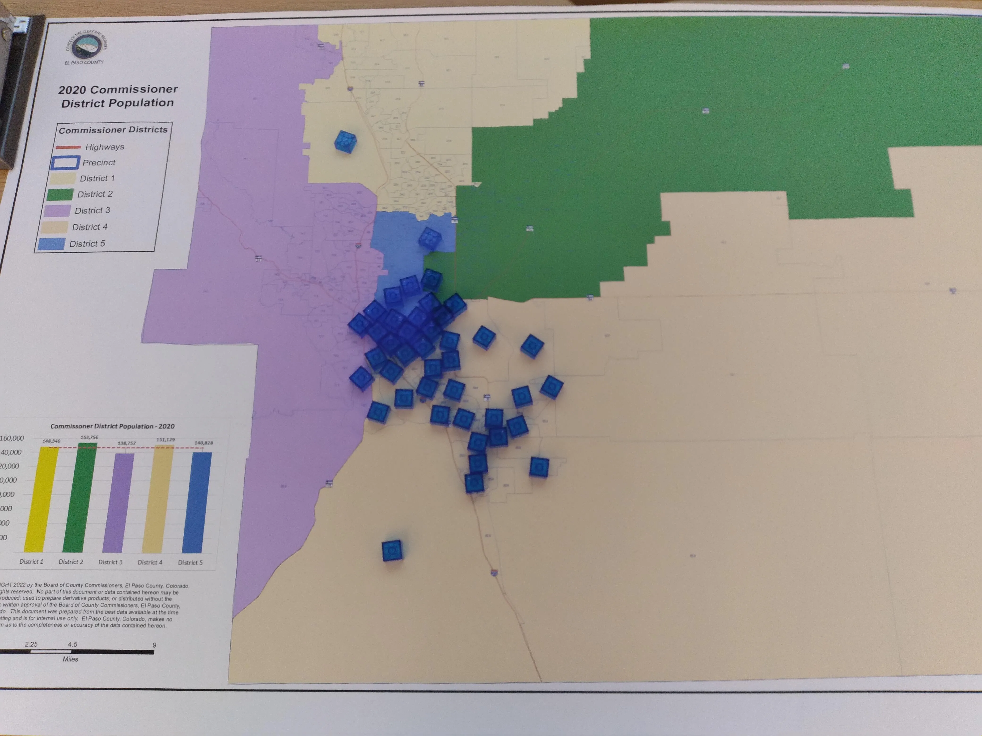
- Review this sample explanation for an approach to submitting your own map (prepared for the El Paso County Commission).
Step 6. Analyze
Analyze redistricting maps, including any maps you created, the existing approved state maps, and various proposed maps in Dave's Redistricting App.
- Read Colorado in Context: Ensemble Analysis and Data Science for Fair Redistricting in Colorado by a group of mathematicians, statisticians, and computer scientists
- Visit maps of the Colorado House and Senate districts.
- Read In re Colo. Indep. Cong. Redistricting Comm'n, Colorado Supreme Court, November 1, 2021
- Evaluate the fairness of electoral district maps using PlanScore, from the Campaign Legal Center.
- Explore the partisan lean data from FiveThirtyEight to consider which party might benefit from a particular map.
- Investigate the Redistricting Report Card, from the Princeton Gerrymandering Project.
Step 7. Learn
Learn about issues in your community that are affected by people who represent you at the local, state, and national levels.
- Who else do you vote with? Who are your elected representatives? How did the lines change from the previous districts? How do your city, county, school board, state, and congressional districts fit together? Did your districts grow or shrink in area? How would you describe your districts (competitive, gerrymandered, representative)?
- Recall the information you identified while describing your community. What else do you need to consider when drawing districts? What watershed do you live in? What school districts serve your area? What issues are decided by state legislatures and local elected bodies that you care about?
- County and municipal jurisdictions are also important to monitor.
County and Municipal Jurisdictions
Arapahoe County Commissioner Redistricting
- Map-making tool amplifies public voice in redistricting process, March 14, 2023
City of Colorado Springs Redistricting
- Final redistricting sets new map for next year's Colorado Springs City Council elections, Brennan Kauffman, The Gazette, November 22, 2024
- Redistricting Survey - share your perspectives with the City of Colorado Springs
- City Council District Process Advisory Committee
- El Paso County Open Data Resources
- Americans Are Leaving Both Parties. This Colorado City Shows Why. David Sides, Politico, June 6, 2024
Denver Redistricting Resources
- El Paso County Redistricting Website
- El Paso County Open Data Resources
- Colorado Springs Board Member Resigns to Focus on New Job, Eric Young, The Gazette, August 7, 2025
- El Paso County Redistricting Tool, Esri
- For background about using geospatial technology to create online redistricting maps, explore resources on the GeoCivics website
- For a sample of a proposed map and explanation about its construction, explore this material prepared by Carlos Perez.
- El Paso County Redistricting Commission finalizes new commission districts; not all pleased, Brooke Nevins, The Gazette, August 15, 2023
- Last chance for feedback: El Paso County Redistricting Commission expected to adopt final map next week, Brooke Nevins, The Gazette, August 6, 2023
- El Paso County Commissioner Redistricting Commission announces more meeting dates for redrawing maps, The Colorado Springs Business Journal, July 20, 2023
- Amid gerrymandering concerns in El Paso County, door could open to rare Democratic seat, Brooke Nevins, The Gazette, July 18, 2023
- Redistricting dilemma: County commission explores ways to consolidate 'communities of interest', including southeast Colorado Springs, Brooke Nevins, The Gazette, July 14, 2023
- El Paso County Redistricting Open House, July 5, 2023
- Hands-on workshop at UCCS will focus on redistricting, mapping software, Brooke Nevins, The Gazette, July 3, 2023
- El Paso County redistricters view proposed maps as residents push to prevent racial, community divides, Brooke Nevins, The Tribune, June 23, 2023
- Residents raise 'gerrymandering' concerns as county Redistricting Commission holds first meeting, Brooke Nevins, The Gazette, June 13, 2023
- Protest Planned During El Paso County Redistricting Meeting, Brooke Nevins, The Gazette, June 12, 2023
- El Paso County Commissioner Redistricting: a modest proposal, Tom Cronin and Bob Loevy, The Gazette, May 27, 2023
- "The significance of how one proposed district fits in with the other four is the topic that needs to be discussed."
- County launches redistricting process, Brooke Nevins, The Gazette, May 13, 2023
Jefferson County
- Meet the Faces of Democracy: George Stern, Michael Beckel and Mia Minkin, Fulcrum, August 16, 2023
Weld County Redistricting
- Colorado Supreme Court rules Weld improperly drew commissioner districts, must redraw lines by 2026 election, Chris Bolin, Greeley Tribune, February 26, 2025
- Weld judge: County commissioners' redistricting failed to comply with Colorado law, Chris Bolin, Greeley Tribune, March 5, 2024
- Weld County commissioners approve new commissioner districts in what some say is violation of state law, Trevor Reid, Greeley Tribune, March 2, 2023
- What suggestions do you have for the people who will draw the lines in 2030?
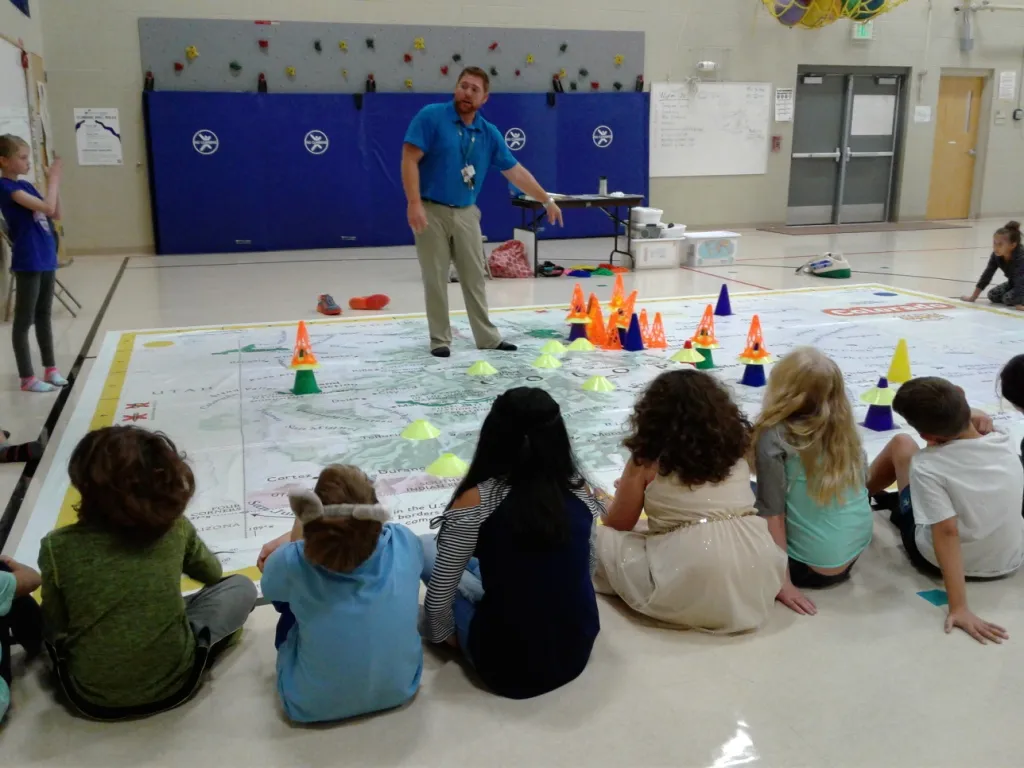
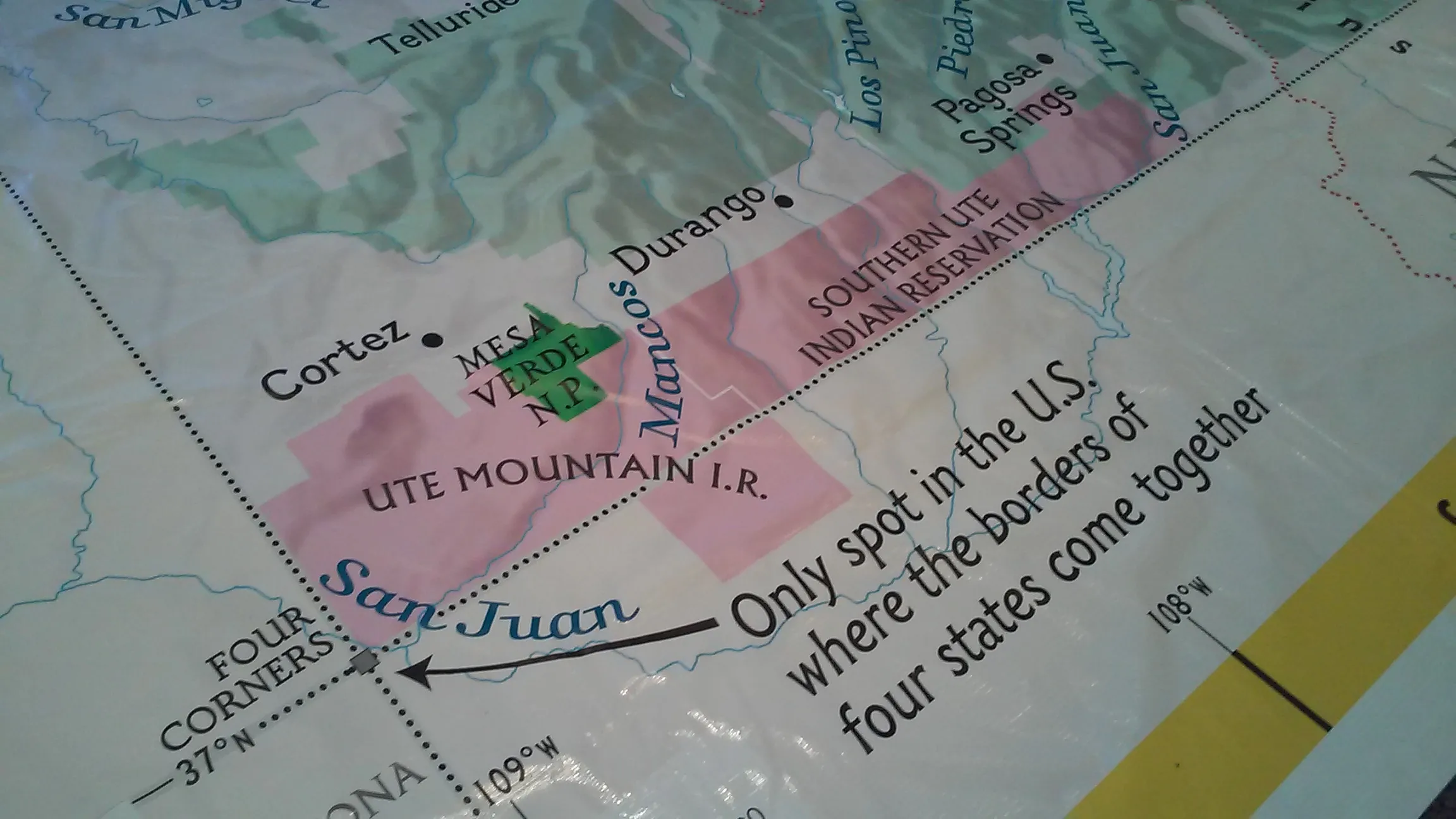
- Locations hosting National Geographic's Giant Map of Colorado
- A User's Guide to Giant Floor Maps: A Colorado Case Study, Rebecca Theobald, The Geography Teacher, Volume 18, 2021, Issue 1, pages 55-72
- Watch students on this video and learn about materials, logistics, and lessons for state giant maps.
- Map of Giant Maps in Colorado
Resources
- Ballotpedia (website with overview and data)
- Colorado Independent Redistricting Commission (official website)
- Colorado Information Marketplace (FSCPE)
- Colorado Map Portfolio, Esri (website)
- Colorado Public Radio Background Resources
- Colorado State Demography Office (website)
- target="blank" Colorado Geospatial Portal (website)
- Peak Progress Quality of Life Indicators, Pikes Peak United Way, October 2022 (data to support describing communities)
- League of Women Voters of Colorado (website)
- Colorado's Innovative and Stellar Election System (information sheet and report - available in Spanish)
- Democrats Realize Good Government Is Bad Politics When It Comes to Maps
- Reid Epstein, The New York Times, April 30, 2026
- League of Women Voters of Colorado
- Louisiana v. Callais Decision Letter, April 29, 2026
- Don't expect Colorado to join the redistricting arms race.
- Kyle Cooke, Rocky Mountain PBS, August 5, 2025
- Bipartisan Legislative Vacancy Reform Bill Passes House
- Denverite, April 23, 2025
- What do teens think about the presidential election? We went into a Colorado classroom to find out.
- Jenny Brundin, Colorado Public Radio, September 26, 2024
- We squished Colorado down to a one-inch thick fudge brownie. Dan Boyce, Colorado Public Radio, April 8, 2024 (physical geography)
- Could Colorado's political journalism be the best in the nation in 2024? Corey Hutchins, Inside the News in Colorado, April 5, 2024
- The Role of Maps in Electoral Redistricting, Rebecca Theobald, Rocky Mountain Map Society, February 27, 2024 (video starting around minute 5:00)
- Colorado is not a Rectangle - It Has 697 Sides
- Frank Jacobs, Big Think, April 14, 2023
- Don't Blame Redistricting for Blue Wave | IN RESPONSE
- Hunter Barnett, John Buckley, Connie Hass and Aislinn Kottwitz, Colorado Politics, November 25, 2022
- Colorado Redistricting With Geographers: Fair Maps and Community Engagement (panel discussion)
- American Association of Geographers, Redistricting Panel Series, What can geographers do?
- Accessible to the public, but requires you to sign in
- Overviews of Redistricting in Colorado
- Eighth Congressional District, Colorado Matters from Colorado Public Radio
- Diving into Colorado's newest Congressional District, April 1, 2022
- Colorado's new Congressional District, April 4, 2022
- Purplish, Colorado Public Radio's Politics Podcast
- Remapping Colorado, The Colorado Sun
- A Look At Colorado's Independent Redistricting Commission, The Takeaway, September 21, 2021
- Eighth Congressional District, Colorado Matters from Colorado Public Radio
- Colorado has finalized its congressional redistricting, but don't forget about your powerful county commission.
- Thy Vo, The Colorado Sun, December 24, 2021
- Redistricting Colorado: What can we learn from how people have been grouped together in voting districts over the past 145 years?
- Julia Jackson and Rebecca Theobald, History Colorado, September 20, 202
- Here are the themes from meetings across Colorado on the state's new congressional, legislative maps
- Sandra Fish and Thy Vo, The Colorado Sun, September 3, 2021
- Remapping Colorado // Census data comes a few days early and the week ahead in redistricting
- The Colorado Sun, August 9, 2021
- Choice Cuts: How competing redistricting requirements will shape Colorado's congressional map
- Evan Wyloge, The Gazette, June 13, 2021
- Want to better understand Colorado's redistricting process? Make your own map.
- Moe Clark, Colorado Newsline, April 9, 2021
- Colorado Independent Redistricting Commission
- Despite Colorado's new redistricting process being independent, there was still plenty of political influence
- Thy Vo and Sandra Fish, The Colorado Sun, November 10, 2021
- Colorado won with new redistricting commissions
- Mario Nicolais, The Colorado Sun, October 24, 2021
- How other states draw their political districts
- Loretta Boniti, In Spectrum North Carolina, August 29, 2021
- State political maps are being redrawn with the help of expert alumna
- Clint Talbot, Colorado Arts and Sciences Magazine, July 22, 2021
- GeoCivics Presentation to Colorado Independent Legislative Redistricting Commission
- Meeting Materials, June 25, 2021
- Fair Districting in Colorado: Where We Are, Where We Are Going, and How We Can Help
- League of Women Voters of Colorado, April 28, 2021
- Discussion of Public Input: Esri Webinar "Delivering a Modern Redistricting Solution"
- See Jessika Shipley's observations at 35:50
- Despite Colorado's new redistricting process being independent, there was still plenty of political influence
Contact
University of Colorado Colorado Springs (UCCS)
Department of Geography and Environmental Studies