
Ohio
Step 1. Review
Review population trends with Ohioans On the Move, an interactive demonstration of population movement in the state over three time periods.
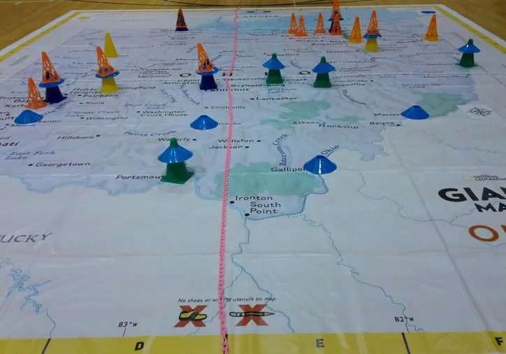
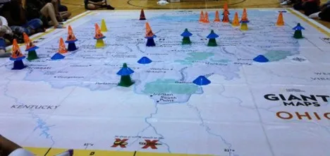
- Watch this video for an overview using National Geographic's Giant Map of Ohio with students and community members.
- Watch this overview of GeoCivics to learn about the variety of approaches (prepared for the 2020 Ohio Council for the Social Studies virtual conference).
- Sinclair Community College Lessons for Giant Map of Ohio
Step 2. Discuss
- Discuss how to prioritize redistricting criteria using Flashes of Insight cards or an online game.
- Redistricting in Ohio: Article XI, Section 1 (background)
Step 3. Describe
Describe and map your community with online tools from Representable.org to understand what issues are important in your neighborhood and region.
Use both written and geographic descriptions to explain your community.
Step 4. Practice

Practice using geospatial technology tools in preparation for drawing sample electoral district lines with accessible, step-by-step instructions.
- What Is a Gerrymander? Investigate Esri's StoryMap, "A geographic exploration of USA's congressional districts"
- Use ArcGIS Online to investigate population in Ohio
Step 5. Draw
Interested in participating in the mid-decade redistricting process? Submit your suggestion for a congressional district map to the Ohio Legislature. Learn about the details here.
Draw electoral districts with 2020 Census data using open-source geospatial technology tools.
- Explore Districtr and District Builder.
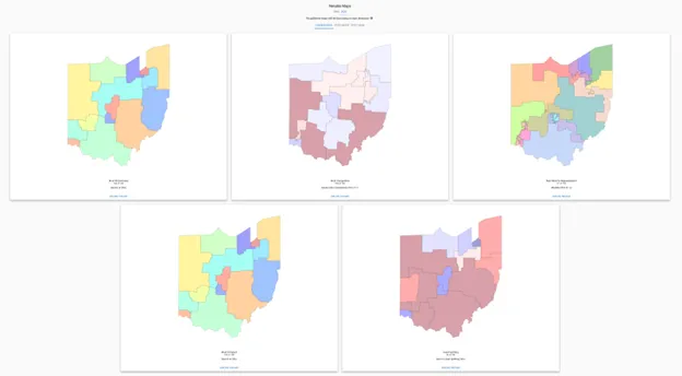
- Examine the "Notable Maps" detailed in Dave's Redistricting App to investigate different approaches to drawing electoral district lines.
Step 6. Analyze
Analyze redistricting maps, including any maps you created, the existing approved state maps, and various proposed maps in Dave's Redistricting App.
- Evaluate the fairness of electoral district maps using PlanScore, from the Campaign Legal Center.
- Explore the partisan lean data from FiveThirtyEight to consider which party might benefit from a particular map.
- Investigate the Redistricting Report Card, from the Princeton Gerrymandering Project.
Step 7. Learn
Learn about issues in your community that are affected by people who represent you at the local, state, and national levels.
- Investigate how local redistricting can be addressed by community members.
- Local Redistricting in Nelsonville, Ohio
- Trevor Martin, League of Women Voters of Ohio, December 2025
- Local Redistricting in Nelsonville, Ohio
- Who else do you vote with? Who are your elected representatives? How did the lines change from the previous districts? How do your city, county, school board, state, and congressional districts fit together? Did your districts grow or shrink in area? How would you describe your districts (competitive, gerrymandered, representative)?
- Recall the information you identified while describing your community. What else do you need to consider when drawing districts? What watershed do you live in? What school districts serve your area? What issues are decided by state legislatures and local elected bodies that you care about?
- Explore this article about questions to ask about your community.
- What suggestions do you have for the people who will draw the lines in 2030?
Resources and perspectives
- Ballotpedia (website with overview and data)
- Ohio Census Data (website)
- Ohio Redistricting Commission (website)
- Ohio Development Services Agency (FSCPE)
- Bowling Green State University, Library Guide on Redistricting (website)
- How Fast Can You Put Ohio Back Together? Chris Kirk and Mark Joseph Stern, June 27, 2020 (article and activity)
- Fair Districts Ohio (website)
- Fair Districts Ohio Announces Winners of the Congressional Mapping Competition, Catherine Turcer, September 29, 2021
- League of Women Voters of Ohio (website)
- Locations hosting National Geographic's Giant Map of Ohio
- Kettering City Schools, Valerie Dupler, valerie.dupler@ketteringschools.org
- New Albany Public Schools, Sandra Reed, reed.11@napls.us
- Oakwood City Schools, Amanda Ammer, ammer.amanda@oakwoodschools.org
- Sinclair Community College, Department of Geography, geography@sinclair.edu
- Worthington Schools, Tricia Merenda, tmerenda@wscloud.org
- Ohio Mid-Decade Redistricting: A Nonpartisan Policy Analysis
- Electoral Innovation Lab, September 2025
- Engaging Community and Growing Partnerships: A Mapping Equity Exhibit in Dayton, Ohio
- Jacqueline Housel, Journal of Geography, September-October 2024
- Untangled, Podcast from All Sides with Anna Staver, Fall 2024
- Report questions 6th Congressional District, Morning Journal, June 10, 2024
- Ohio Governor DeWine lost all credibility when he repeatedly voted for illegally gerrymandered maps
- David Dewitt, Ohio Capital Journal, July 31, 2024
- How old fire insurance maps and machine learning are helping to recreate lost neighborhoods
- Bill Rinehart, WVXU, July 27, 2023
- Mapmaker, Mapmaker, Make Me a Map
- Ira Glass, This American Life, November 4, 2022
- Mapping out our "ghost neighborhoods"
- Tyler Buchanan, AXIOS Columbus, September 26, 2022
- Win, Lose, Draw: Inside Ohio's Redistricting Battle
- Jim DeBrosse, Cincinnati Magazine, August 15, 2022
- A timeline of Ohio's redistricting saga
- Andy Chow, WOSU, May 13, 2022
- Ohio Redistricting With Geographers: New Criteria and Communities of Interest (panel discussion)
- American Association of Geographers, Redistricting Panel Series, What can geographers do?
- Accessible to the public, but requires you to sign in
- All Sides with Ann Fisher, WOSU Public Media (podcasts)
- Ohio to draw new political maps -- and it's the most important decision in the last 10 years (article)
- Laura A. Bischoff, Dayton Daily News, March 14, 2021